
< Back to Cove Guest Info / FAQ
Driving Directions
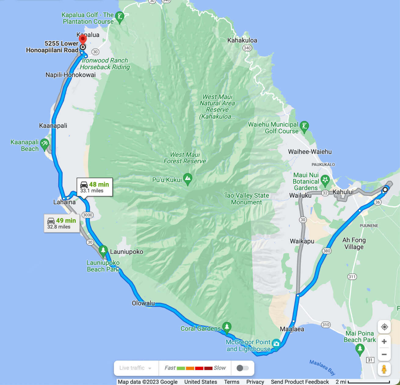
The following driving directions assume that you picked up your rental car from one of the major car rental agencies at Kahului Airport. The route is shown on the image below, courtesy of Google Maps. It circles the West Maui mountains in a clockwise direction and follows the Lahaina Bypass on its way to Honokeana Cove. You may click the image for a higher-resolution version.
Ask at your car rental counter for one of their map books, and for how to get on Highway HI-380 (Kuihelani Hwy) going toward West Maui.
Alamo, Avis, Budget, Enterprise, Hertz, National and other companies are all located in the rental car center at Kahului airport. As you leave the car rental office follow the signs to the main airport access road highway HI-380, also called Kuihelani Highway. Continue for 5.2 miles.
You will arrive at a T-intersection with a traffic light. Use either lane to turn left onto Highway HI-30, southbound. After you turn left, the right lane will disappear, so be prepared for a merge. Continue on HI-30 for 12.3 miles. During the last quarter-mile the road will turn inland, away from the ocean.
Continue straight through the intersection. You are now on Highway HI-3000, the Lahaina Bypass. This highway was built just for you, to make your visit easier by bypassing the heaviest Lahaina traffic, and by bypassing a frequently flooded portion of the coastal road. Continue 4.8 miles on the Bypass.
The road turns left and you are now on Keawe Street. Continue 0.2 miles and you will approach an intersection with traffic lights. The road crossing you is HI-30, here called Honoapi’ilani Highway. It is a continuation of the highway you took around the West Maui Mountains.
You now have a decision to make. Just in front of you is the Lahaina Cannery Mall, a large shopping center. This center has Long’s Drug Store (which is actually a CVS drug store). It also has Safeway, a relatively well-stocked supermarket that is generally open late into the evening. If you want to stock up your supplies, you may wish to go straight through the intersection for Long’s, or turn right and then turn left at the next traffic light for Safeway. Otherwise, you can just turn right at the traffic light and continue directly to Honokeana Cove.
These directions assume that you turned right at the intersection, completed any shopping center business, and are now back on the highway.
Continue 7.5 miles on HI-30 through several traffic lights.
As you approach 7.5 miles you will be coming up a hill to a traffic light. On the right is a marker for Mile 29 on the highway. On your left is the Napili Plaza shopping center.
At the light, turn left onto Napilihau Street, toward the ocean. Proceed 0.3 miles.
You will come to a T-intersection with a stop sign. Turn right onto Lower Honoapi’ilani Road. This is the coastal road serving the areas of Honokowai, Kahana, Napili and Kapalua. Honokeana Cove is located in Napili.
After you turn right, proceed 0.3 miles. You will pass only one street on the left, which is Papaua Place. Just after that, the road bends to the left and the Honokeana Cove driveway is right there on your left. Look for the wood Honokeana Cove sign featuring a stylized turtle logo. At night there are lights shining on the sign to make it more visible.
You may park in any space without a sign.